Monday, February 27, 2006

The Making of the English Landscape


Would it be sad to say that one of my 'comfort' books is 'The
Making of the English Landscape' by W G Hoskins. I think I read in the flyer that one critic said that it was rare that a single book comes along and heightens your consciousness of your surroundings. That's why every now and then I have to dip back into it to bring me back to that ethereal state of awareness - or else I'm in danger of being numbed by the effects of today's busy and stressful lifestyle.

I think the book was originally written in the 1950's but it is still revolutionary in its outlook - with its main tenet that even the wildest moors of Britain have been shaped by the hand of man. Even more remarkable is the fact that with a little insight you can still see the marks that our ancestors left over 10,000 years ago.

Boundaries are one of the most lasting features in our landscape, as are some field systems.

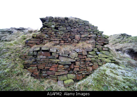
The photo above of
Cheesden Pasture in Heywood Lancs shows a largely rural scene which most would expect to be completely natural. But we have a field boundary of stone; a cultivated pasture to the right; a tree (which is at the base of the ruins of a house and probably planted by man); just off photo, some larger humps and bumps were created in the late C18th and early C19th when water was diverted to a lodge to run a water powered mill. On the side of the hill in the background there survives a series of ridge and furrows which are only visible when the sun is low (from what period I don't have a clue). The main ridge in the photo leads to a hill which has had human activity for thousands of years with stone age flints being found (possibly a place of ritual) Nearby across the Edenfield Road we have a bronze age burial site which lifts the field boundary aloft like the dip of a roller coaster. Only a matter of yards away the head of a bronze age axe was found during excavations for a reservoir.

Indeed it wouldn't surprise me to find out that this area of North Pennine Moors was teaming with life several thousand years ago and that the location of my home town would have been no more than a clearing swamped and surrounded by trees.

Tuesday, February 14, 2006

The Brook at Deeply Vale

Remarkable it is to see the Brook at Deeply Vale at full pelt. Swollen with fall off from the North Pennine Moors, it rattles its way along the Deeply Vale section like a bob sleigh. For over 200 metres the river has been laid with beautifully hewn sandstone setts and bordered with an imposing 2m high dry stone wall. It must have been a remarkable enterprise - no doubt the builders would have had to damn the river and re-direct it during construction.


I was brave and climbed into the river to take a few photographs and walked its full length to the top where the remains of a stone jamb to hold a sluice gate leans over tentatively.


I have produced a Google Earth archi-map of Cheesden where you can view the location of the Deeply Vale Mill and Brook which flows past.

Sunday, February 05, 2006

Cheesden Pasture Mill


History


Built around 1810 for carding and spinning wool. The mill was powered by water from the large triangular lodge situated several feet above the mill. It converted to cotton spinning in the late 1830's whereafter the factory was enlarged to incorporate several thousand spindles. Sandiford and Asworth note 3 to 4000 spindles for spinning cotton waste yarns, 3 pairs of mules for spinning raw cotton and 5 reeling frames for winding the spun yarn into hanks in preparation for the dyer. In addition 30 looms made cloth from the spun yarn.

Here we can witness in one mill the transition from industrial unit focusing on producing wool for the outworker, to multi-faceted industrial unit focusing on producing cloth in a variety of forms and ranges - reeling in the majority of processes under one roof.

During the peak of its production a row of cottages were built to house workers. Later a steam engine was incorporated into the factory which helped produce gas to light the mill. A school room was also incorporated indicating the important role of the mill in the northern outback, in social matters during this time.


Remaining Archaeology

Little remains of the mill (although more than I expected). The plan form can still be made out (if one consults Sandiford and Ashworths drawings) against the hillside. The biggest remaining impact of the mill is on the landscape, with the huge earth banks of the lodge rising high above a rubble stone revetement. It remains empty, and was filled by the numerous springs in the area, and not the brook itelf. An opening in the south west corner indicates where the waterwheel must have been. Also, a large oval indentation is present to the north which may have housed a boiler or gas tank of some description. Whilst I was up there I found the remains of a china tea-cup (surely not from the mill or outworkers buildings?). Iron pipes protrude from behind a stone revetment or wall tucked up against the lodge. Beyond the great oval indentation the stone remains of a square building survive. To the east of the lodge, humps and bumps and some slight standing walls indicate the location of the row of houses. Of interest to me are the remains of a Shippon which looks suspiciously like a ww2 air raid shelter.


Project Links

Touched by the hand of God
Shippon at Cheesden Pasture Mill


Lightbox (updated regularly)

Images of Cheesden Pasture Mill

Location

You can view all of the Cheesden Valley mills on my Google Earth archi-map.
Access is from my archi-map page on my website.


Satellite Image of Cheesden Pasture courtesy of Google Earth


Do you have more information?

Please post a comment if you have more information or any corrections are required

References

There are a number of references which require acknowledgement. Firstly the pioneer book by A.V. Sandiford and T.E. Ashworth called The Forgotton Valley is an important source of information and is available from the libraries at Heywood or Rochdale. For a general background Owen Ashmore's Industrial Archaeology of Lancashire is a must. There is also a good archive at Heywood Library.

Wednesday, February 01, 2006

Farmstead

The farms around the North Pennine Moors in the north of England are almost prairie like and the vast haunch of of moss gnarled sandstone coal measures adds an epic quality to the landscape.

I was up there last Sunday to witness this spectacular sunset and take my wife and daughter for a walk up to a small hamlet called Fecit via the Cheesden Pasture; where I told them stories of the ardent activities of the mill operatives who traversed the stark setting every morning to sit at the loom and stare out of the window at the farm on the horizon silhouetted against the ochre sky.