Friday, March 24, 2006

The Lodge at Four Acre

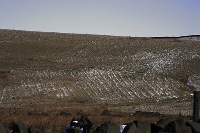
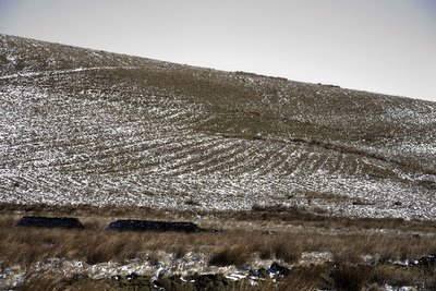
How about this for an archaeological profile? This must be an archaeologists dream with the full section exposed and not much digging to do!

This is an eroded section of the lodge bank at Four Acre Mill in the Cheesden Valley Heywood near Lancashire. It is adjacent to the outlet where the water would have driven the water wheel at the Mill situated a matter of yards lower down. The lodge was built before 1810 for the mill which started its life carding and spinning wool. Remains still exist of the mill amounting to a low rubble wall and much scattered debris. A hole which I think might come from the tail race in the bank below is taken up by a fox or badger.


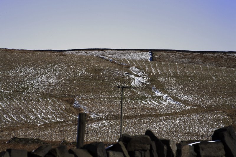
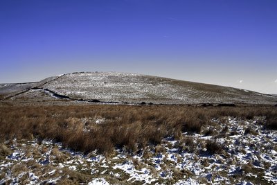
In the photo above you can see the full outline of the lodge and the indentation where water would have collected to power the waterwheel.

The valley is full of the signs of mans endeavours to utilise the landscape to help him prosper. It was only recently that I noticed a whole range of ridge and furrow around the area known as Tom Hill.

I am currently carrying out a project to photograph the Cheesden Valley and it has its own separate blog.

There is a Google Earth map of the valley which I have created. You can download it at my archi-maps page here.

Monday, March 13, 2006

Below the bridge at Crostons

This was the scene a week ago or two, below the bridge (more like a conduit) at the site of Crostons Upper Mill in the Cheesden Valley Heywood Lancashire UK


Wednesday, March 08, 2006

The Lodge at Mr John's

Here are the remains of the lodge used to drive the mill at Cheesden Lumb Higher (affectionately known by contemporaries as Mr John's). The lodge isn't so easy to see during the summer and the snow helps add a little relief to see the contours. It lies empty now, but I imagine it would be treacherous to try and walk into the centre. In the south east corner lumps and bumps reveal the site of the mill. Directly to the south a wall stands with holes inserted at regular intervals where the rafters would have been lodged to support the floor.

Monday, March 06, 2006

Lumps and Bumps

A light dusting of snow over the North Pennine Moors (near Heywood Lancashire UK) revealed extensive marks which look like ridge and furrow. What date they are from is difficult to say and whether they have been ploughed or produced for drainage is also difficult to say. I have looked on Google Earth and several field systems of ridge and furrow are visible crashing into each other at various angles to the south of Tom Hill between Cheesden Pasture and Cheesden Fold. Some respect the current field boundaries and some do not. Below are some pics I took on Saturday.

Below is a picture of Tom Hill which is covered in ridge and furrow. Ridge and furrow to the west are cut into by Victorian ventilation shafts showing that they pre-date this period. There is an unusual irregularity as to their positioning and pattern.

All over the area there are derelict farms and barns - the footprints now only survive. It would be fascinating to find out about the history of this area and how the landscape has developed. I'm sure it would add to an area which is poorly documented.

Interestingly, on the Google Earth map there is just visible beneath the pattern of one furrowed field a series of rectangular marks (enclosure?) which possibly predate the ridge and furrows themselves. They lie on the south slope of Tom Hill. I have marked the area on my google earth archi-map (Cheesden Valley) and you can see them for yourself if you download the map here.

Tom Hill from the South West

Saturday, March 04, 2006

Cheesden Lumb Even Lower

I went out the site of Cheesden Lumb Lower today because it had snowed the night previously and it helps define much of the archaeology.

Recently I have noticed a deterioration of the site which seems to have been made worse by a surge of water or flooding of some kind. Where the axle to the waterwheel was - we now have huge sandstone rocks and boulders. To the front of the mill the earth has caved in leaving a large circular chasm. The foundations beneath the doorway have been revealed and I can't help feeling that it wont be long before the facade collapses.

Wednesday, March 01, 2006

Cheesden Pasture Ridge and Furrow

On Monday I talked about how our landscape has been changed by man over thousands of years; and noted that during a walk on Cheesden Pasture near Heywood Lancs UK that along the side of one of the ridges there magically appeared a series of ridge and furrow.

This was whilst the sun was setting and they disappeared after a few minutes. They're completely invisible to the eye most of the time. Anyway I took a hurried and shaky hip shot with the zoom lens and here they are - click the pic for larger view.